Hurricane Ian nears Cuba on path to strike Florida as Cat 4
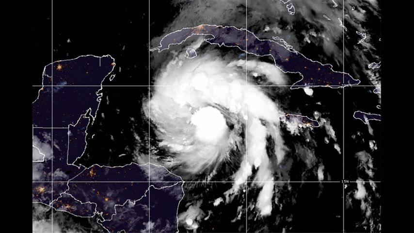
HAVANA (AP) — Hurricane Ian was growing stronger as it approached the western tip of Cuba on Monday, on a track to hit the west coast of Florida as a major hurricane as early as Wednesday.
Ian was forecast to hit Cuba as a major hurricane and then become an even stronger Category 4 with top winds of 140 miles (225 kilometers) over warm Gulf of Mexico waters before striking Florida along a stretch of coast including the Tampa Bay area.
"Please treat this storm seriously. It's the real deal. This is not a drill," Hillsborough County Emergency Management Director Timothy Dudley said at a Monday news conference on storm preparations in Tampa.
Authorities in Cuba suspended classes in Pinar del Rio province and planned evacuations Monday as Ian gained strength on approach to Grand Cayman and the Cuban provinces of Isla de Juventud, Pinar del Rio and Artemisa. Cuba also was shutting down its train system ahead of the worst weather.
"Cuba is expecting extreme hurricane force winds, also life threatening storm surge and heavy rainfall," U.S. National Hurricane Center senior specialist Daniel Brown told The Associated Press early Monday.
At 11 a.m. EDT on Monday, Ian was moving northwest at 13 mph (20 kph), about 240 miles (385 kilometers) southeast of the western tip of Cuba, with top sustained winds increasing to 80 mph (130 kph).
As the hurricane approached the Cayman Islands, members of the government and opposition were working together "to ensure that our people are made as safe as possible -- the supplies, plywood, in some cases sandbags, are distributed so that they can safely weather this storm," Premier Wayne Panton said in a video posted Sunday. "We must prepare for the worst and absolutely pray and hope for the best."
"Ian is not expected to spend much time over western Cuba, and additional strengthening is likely over the southeastern Gulf of Mexico on Tuesday," the center said. "Ian is likely to have an expanding wind field and will be slowing down by that time, which will have the potential to produce significant wind and storm surge impacts along the west coast of Florida."
A surge of up to 10 feet (3 meters) of ocean water and 10 inches (25 centimeters) of rain was predicted across the Tampa Bay area, with as much as 15 inches (38 centimeters) inches in isolated areas. That's enough water to inundate low-lying coastal communities.
Florida residents were getting ready, lining up for hours in Tampa to collect bags of sand and clearing store shelves of bottled water. As many as 300,000 people may be evacuated from low-lying areas in Hillsborough County alone, county administrator Bonnie Wise said at a news conference Monday on preparations.
Some of those evacuations were beginning Monday afternoon in the most vulnerable areas, with schools and other locations opening as shelters. "We must do everything we can to protect our residents. Time is of the essence," Wise said.
A hurricane watch was issued for Florida's central western coast including the Tampa Bay area, where Hillsborough County suspended classes through Thursday to prepare schools to serve as shelters for evacuees. Additional watches for more northern areas along the peninsula's west coast may be issued, Brown said.
Gov. Ron DeSantis has declared a state of emergency throughout Florida and urged residents to prepare for the storm to lash large swaths of the state with heavy rains, high winds and rising seas.
President Joe Biden also declared an emergency, authorizing the Department of Homeland Security and the Federal Emergency Management Agency, or FEMA, to coordinate disaster relief and provide assistance to protect lives and property. The president postponed a scheduled Sept. 27 trip to Florida because of the storm.
Flash and urban flooding was predicted for much of the Florida peninsula midweek, and then heavy rainfall was possible for the southeast United States later this week. With tropical storm force winds extending 115 miles (185 kilometers) from its center, watches were issued Monday from the Florida Keys to Lake Okeechobee.
As of Monday, Tampa and St. Petersburg appeared to be the among the most likely targets for their first direct hit by a major hurricane in a century.
Bob Gualtieri, sheriff of Pinellas County, Florida, which includes St. Petersburg, said in a briefing that while no one will be forced to leave, "mandatory" evacuation orders are expected to begin Tuesday.
"What it means is, we're not going to come help you. If you don't do it, you're on your own," Gualtieri said.
The evacuation zone is all along Tampa Bay and the rivers that feed it, encompassing MacDill Air Force Base, Tampa International Airport and well-known neighborhoods such as parts of Hyde Park, Davis Islands and Ybor City.
St. Petersburg Mayor Ken Welch urged residents not to ignore any evacuation orders. "This is a very real threat that this storm poses to our community," Welch said.
The hurricane center has advised Floridians to have hurricane plans in place and monitor updates of the storm's evolving path.
___
Associated Press contributors include Curt Anderson in St. Petersburg, Fla., and Julie Walker in New York.


